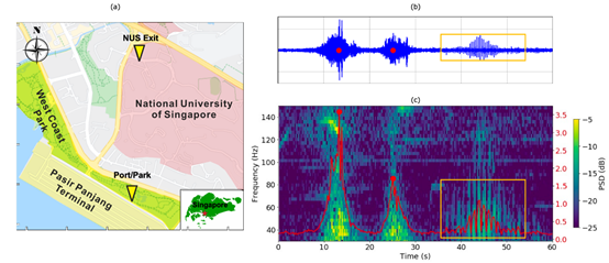
Seismological Urban Activity Monitoring in Singapore Under the Influence of the COVID-19 Virus
Equipment Used: IGU-16 HR3C 5Hz Number of Devices: 2

Seismological Urban Activity Monitoring in Singapore Under the Influence of the COVID-19 Virus


Equipment Used: IGU-16 HR3C 5Hz

Number of Devices: 2


1. Background Overview

Urban activities induce minor vibrations on the Earth's surface, detectable by highly sensitive seismometers. In Singapore, since April 2020, significant changes in human activities have occurred due to government measures to suppress the spread of COVID-19. The impact of the pandemic and corresponding mitigation measures has been quantified using traffic flow data at the National University of Singapore (NUS) and the intersection of Pasir Panjang Port Terminal and West Coast Park, representing activities in non-essential workplaces, essential workplaces, and recreational areas.


2. Study Features

 image.png

(a) Map of the Study Area

Two yellow triangles represent the locations of two high-frequency SmartSoLo seismometers—one at the exit of the National University of Singapore campus and another at the intersection of Pasir Panjang Container Terminal and West Coast Park. The red star on the map indicates the study area's location on Singapore Island.


(b) Example of 60-second Data Recorded on April 18, 2020 (GMT+8) at the Port/Park Location

Data, filtered between 30 and 150 Hz, clearly show signals from two prominent motor vehicles (red dots) and a runner (orange box) against the background.

 image.png

(c) Spectrogram of the Time-Domain Signal in (b)

Motor vehicles generate short-duration vibrations across the entire frequency band. Rotating wheels produce long-duration periodic spike signals. The red line represents the total PSD between 40 and 100 Hz, identifying individual large peaks as motor vehicles and periodic events as runners.


Traffic Flow Detected by SmartSolo Seismometers at the National University of Singapore Campus


(a) Number of Motor Vehicles Detected per Hour from April 8 to August 30, 2020

(b) Daily Motor Vehicle Count

The black dashed line represents the percentage change in workplaces according to the Google Mobility Report.

(c) Average Number of Motor Vehicles per Hour on Weekdays

(d) Average Number of Motor Vehicles per Hour on Weekends

In (a) and (b), the red solid line indicates the start of the Circuit Breaker (CB), while the short dash and dot-dash lines represent the beginning of Phase 1 and Phase 2, respectively. In (c) and (d), data recorded during CB (Weeks 1-8) and after (Weeks 9-21) are represented by blue and red dashed lines, respectively. Lighter shades indicate earlier times. The thicker red and blue solid lines represent the average number of vehicles for the respective periods, with the shaded area covering twice the range of the standard deviation above and below the mean.

 image.png

Traffic Flow Detected by Pasir Panjang Port Seismometer (Legend same as above)

 image.png

Runner Count Detected by West Coast Park Seismometer (Legend same as above)


3. Research Findings

The stealthiness of SmartSolo seismic data, coupled with unprecedented spatiotemporal resolution, is crucial for understanding the heterogeneity and evolution of pandemic responses across different sectors of urban society. The rich information extracted from seismic data presents a unique opportunity for real-time activity monitoring and dynamic policy formulation, ensuring successful pandemic mitigation while minimizing the negative impact on urban lifestyles.


We're active on social media!
Stay informed with our latest updates by following us on these platforms:
Twitter
Facebook
LinkedIn
YouTube
Case Study Summary
Application
Location
Products Used
Contributors
Participating Organizations
Measured Parameters
Related Website